
Maremma: the Silver Coast |

|
||

| |||
| |||||
 |
Maremma: the Silver Coast | ||||
| The Costa d'Argento is the marvelous part of the Tuscan coastline south of Grosseto. It is bordered by the Uccellina Hills and Lake Burano, both splendid and unique natural environments. | |||||

| Related images (4) |
|
The Aurelia State Highway runs lengthwise, following the route of the original Roman road from the warm, health-giving source of the Osa as far as the foot of the hill with the magical Tarot Garden. Here and there, roads cross it, leading to the hill or the sea. The ancient towns of Montiano, Magliano and Capalbio, closed within solid city walls, once guarded the costline and countryside from their perches on high. Today these towns are the custodians of past rituals and traditions that give quality to life. Orbetello overlooks the flourishing lagoon, teeming with fish and birds. Every corner inside the massive city walls calls forth memories of itsd past: an Etruscan and Roman city, a rich medieval abbey, and the unconquered capital of the Spanish Presidios and, more recently, as the base for legendary flights that opened the Atlantic skies to man. The Argentario, which gives its name to this section of coast, is a green mountain reaching up from the waves. Once an island, it became connected to the mainland by way of the tombolos of Faniglia and Giannella. It is now an environmental and seaside vacation paradise. Along with Talamone. That faces it to the north, the Argentario is the preferred spot for nautical tourism. In the fishing villages of Porto Santo Stefano and Porto Ercole, it is possible to go to sea in any season, taking the same routes followed by different peoples and civilizations from time immemorial. In these towns, traditional shipyards and boat-builders still pass down the noble art of building wooden boats. Two small islands stand off the coast. The larger, the island of Giglio, has a wild granite coast, broken here and there by cultivated terraces. The smaller, the Island of Giannutri, was dedicated to the moon in ancient times and an Imperial Roman villa is said to hold the secret of a mysterious love story. The dense Mediterranean scrub climbs along the sheer cliffs that hide the charming coves of the Argentario from view until it reaches the Hermitage of the Passionists and the summit where the eye sweeps from the Amiata to the mountains of Lazio and on to the distant silhouettes of Montecristo, Elba and Corsica.
CAPALBIO Clinging to the top of a wooded hill, Capalbio is the first castle city in the Maremma, located at the border to Lazio drawn by the the Chiarone River and the old Papal Customs. The village still exudes the rustic atmosphere of farmers, hunters and bandits from more than a century ago. The present name Capalbio apparently comes from “Caput Album” (bald head), mentioned in the 1161 bull issued by Pope Alexander III decreeing that it become part of the Abbey of the Tre Fontane, as Charlemagne had previously decided in about 805. It is possible to establish the construction of the castle between these two dates. It was subsequently further improved upon by the Aldobrandeschi family (1183) and the Orsini (1236). Between 1416 and 1555, under the dominion of the Republic of Siena, the town was provided with the final, exterior circuit of wall, known as Porta Senese, a double vaulted structure, topped by a tower which was later enchanced with the clock. Capalbio was part of the Grand duchy of Tuscany and after passing under the dominion of the Lorraine, it slowly declined both economically and demographically. This gave rise to a period of banditry that continued until the 19th century. It is believed that Tiburzi, the most famous bandit in the Maremma, whose escapades became legendary, spent most of the time he hid from the law in Capalbio. Passing through the narrow medieval streets within the city walls you can see the Arco Santo topped by a bust of the Emperor Hadrian and the 13th century Church of San Nicola. An inscription recording the restoration in 1466 is visible on the Gothic arched portal. The interior has lateral chapels and a squared apse at the end of the nave. Opposite the church is the fortress connected to Palazzo Collacchioni, where a piano played by the famous Italian composer Puccini is preserved in the hall named after him. Just outside the interior wall of the Oratorio della Provvidenza is a fresco by the school of Pinturicchio from 1510 portraying the “Madonna and Child between Saints Jerome and Siegmund”. On the knoll Capalbiaccio, to the west of Capalbio, there is another antique “castrum” that became the Castle, now known as Tricosto. Today some of the outside enclosing wall and the ruins of a church still remain. The hills of Montieri rise to the northeast of the town and it is believed that the first inhabitants of Capalbio came from there. In the neighbourhood there are, indeed, remains of some Roman villas dating from the 1st century. One of these, on the low hill of Settefinestre, has an imposing cryptoporticus and a hanging garden bounded by small towers of excellent design.
MAGLIANO IN TOSCANA Magliano, Hepa or Epa for the Etruscans, Heba for the Romans, was a bastion first for the Aldobrandeschi, then for the Sienese, followed by the Medici and the Lorrain. Today the wall and embattled towers look over olive groves and vineyards stretching to the sea, sycamores, broom and wheat where the northwest wind blows. Here you can walk, cycle and horseback ride around the ruins of San Bruzio, one of the loveliest Romanesque churches of the 12th century, rising between majestic cyoresses, grapevines and the remains of the Etruscan tombs, Santa Maria in Borraccia, carved in the rock. The old Roman road leading to the painted Tomb of the Chimaeras from the 6th century A. D starts here and crosses planted fields to its destination. This land, coveted by the mighty, has preserved the “Piombo” di Magliano, a lenticular metal sheet inscribed on both sides with the names and laws of ancient deities and religious rites; the bronze “Tabula Hebana” and the “Cippo” delle Sassaie, now located in the garden next to the City Hall. The importance of these documents reminds us of the historic and cultural value of this archaeological area which is so full of significant examples of the social organization of the Etruscan people. The facades and the coats of arms of Palazzo dei Priori and Palazzo del Capitano and the mullioned windows of Palozzotto di Checco il Bello tell us about Magliano's other princes. The religious monuments are also many: The Church of San Giovanni is sober and elegant and its rose window, brackets, cornice and capitals in travertine reveal the simple and refined architectural style of Francesco di Giorgio Martini (1439-1502); the spare Romanesque Church of San Martino, Magliano's first parish; the Church of the SS. Annunziata, of ancient origin, probably built on top of a Roman villa, ceertainly an oratory dedicated to the Madonna del Latte, portrayed in the frescos inside and in the lovely painting by Neroccio. The sunset's rays illuminate the simplicity of these forms and the beauty of the stones of Portanova, Porta San Martino, Porta San Giovanni and the belltower overlooking all. The village of Pereta is only a few kilometres from Magliano. It was built by the Aldobrandeschi between the 10th and 11th centuries as a military centre for the surrounding area. Typical Maremma landscape envelopes the small town and its imposing entrance gate gives onto ancient, narrow and quiet streets leading to the 16th century Clock Tower, passing by the Church of San Giovanni Battista and the small Church of Santa Maria. The authentic medieval atmosphere grows not only from mighty buildings, but from legends of knights, minstrels and balladeers as well.
MONTE ARGENTARIO The township of Monte Argentario is cradled by the mountain from which it gets its name. It is surrounded by water and just into the sea, protecting the land to which it is attached by the tombolos of Feniglia to the south and Giannella to the north. This unique promontory, once an island, has preserved the historic, artistic and environmental treasures of its two towns, Porto Santo Stefano and Porto Ercole.
Porto Santo Stefano The larger of Monte Argentario's two towns is Porto Santo Stefano. The town descends along the slopes of the hillside to the picturesque bay on the northern coast. It has become a well-known and popuar seaside resort thanks to the splendid sea and natural beauty that surround it. Lovely villas antique watchtowers are built against the hillside around the gulf, while the steep cliffs and ravines of the coastline are broken by terraces of vineyeards and the ever-present Mediterranean scrub. Thanks to its two ports, Porto Nuovo and Porto Vecchio, the town maitains a busy commercial and tourist activity based on yachting and on the transportation services to the islands of Giglio and Giannutri. Shipyards and traditional wooden boat building are also important. The cove of the Valle is followed by that of the Pilarella, which in Roman time, was the port of departure for the ships directed to the patrician villas in Giglio and Giannutri. Historical documents show that Santo Stefano was founded between the 15th and 16th centuries by Ligurian and Alban fishermen who settled there to fish and cultivate the land. The population increased at the beginning of the 17th century when the governor of the Stato dei Presidi (Garrison State), Nuno Orejon, made it the base for a large fleet of sailing ships. During this period the most important structure of the town, the Rocca Spagnola was constructed. The fortress, in Aragonese style, has a square plan with a drawbridge and walls with sloping reinforcement and might be considered more of a tower than a fortress. The other Spanish watchtowers surrounding the peninsula, like silent witnesses to its military past, now guard the lovely coves and sparkling water below. The grand and mysterious Forte is located in Pozzarello. It is known for its sturdy bastions and ramparts for which the district has been named. The oldest tower, the Argentiera, that many say has given its name to the entire area, rises behind the Valle. It served as the Sienese foundry for the silver that was to be in the area. Almost on top of the mountain, before entering Santo Stefano, a religious retreat appears, wrapped in the thick Mediterranean scrub. This is the Convento dei Padri Passionisti, one of the most beautiful convents in the Maremma. 2500 metres above the sea, this enchanted place was frequented by hermit monks starting in the 5th century A. D. It was rebuilt in the 18th century and became the seat of the monastic order of the Congregazione della SS. Croce or the Padri Passionisti. A painting by the famous Manciano artist Pietro Aldi portraying San Paolo of the SS. Croce in an ascetic pose can be found in the chapel of the convent.
Porto Ercole It isn't easy to choose the perfect spot to begin exploring Porto Ercole. Although it has become an important resort, it has lost none of its charm. The old seaside village has kept the extraordinary range of colours and fragrances associated with the sea and the people, their history and traditions. So, inevitably, the tourist who arrives, whater the season, must let himself be led by the voice of the sea. And the voice of the sea in Porto Ercole is an old voice that speaks many languages, as many as the peoples who came here to live in epoch after epoch: from the Phoenicians, whom they say founded it in the remote past, to the Etruscans and Romans who named it “Portus Herculis” in honour of the mythological hero, to the Spanish whose heritage can be clearly seen in the fortifications built during the period of the Stato dei Presidi in 1557. Hence the Rocca that dominates the town from above and in whose interior so much of the history of the town took place, creating a consistent defence system around the town and encircling the entire settlement in a protective wall. From the Rocca, following the wall, you go down to the old town: a maze of tiny streets and twisting lanes with steep stairways and dark vaults that pass between the small, picturesque houses. You enter the town through the old gate topped by the clock tower, or directly from the Rocca, along a rough but enticingly panoramic path, shaded by marine pines and invaded by the Mediterranean scrub. The Palazzo del Governatore looks onto the small piazza Santa Barbara in the lower part of the town, above the bastion of the same name. The Palazzo was built at the beginning of the 16th century under Sienese rule and during the Spanish domination became the residence of the Governor of the Presidio. The Church of Sant'Erasmo is located in the upper part of the old town. It is an excellent example of 17th century Spanish architecture. In front of the Rocca, on the promontory that overlooks the new part of the town, stands the Forte San Filippo. This formidable fortification was built for Phillip II using the most advanced military techniques of the period. It has deep moats, dungeons, watchtowers and a drawbridge that still convey the idea of fort's impregnability. The Forte di Santa Caterina and the Forte Stella are a short distanmce away. The latter completes the itinerary of the defence structures and owes its name to its original and perfect six pointed star shape. The traditions and life-style of the town are present in the special atmosphere along the docks in the port. The fishing boats return every evening at sunset and the seafront fills with the thousand voices, aromas and colours of the fish market, making a stroll in the light of the setting sun all the more pleasurable.
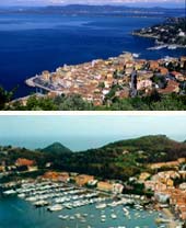
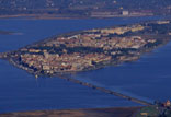
ORBETELLO The city stands on a small peninsula surrounded by the Levante and Ponente lagoons which are divided by an artificial embankment that, since 1841, unites it with the Promontory of Monte Argentario. The lagoons are closed by two fingers of land called the Feniglia and Giannella tombolos, providing the visitor with kilometres of lovely beaches. Seen from above, the city resembles the prow of a ship anchored in the lagoon's still waters and attached to the promontory as if by a gangplank allowing passengers to disembark. The remains of the polygonal wall demonstrate that it was already settled in Etruscan times. It was conquered by the Roman Empire from which its name derives, although there are still many questions in this regard: Orvelus, Urva Tellus, or Urbis Tellus? Circular city, city of herbs or city of Rome? The doubts remain, also because the city's archives were sacked in 1455. It was and is, in any case, a city on the sea and because of its particular geographical position, it has always been a much-desired conquest, not only by noble Italian families, but also by foreign states. After having passed from the Orsini to the Republic of Siena, in 1555 it was occupied by the Spanish who proclaimed it capital of the Stato dei Presidi and proceeded to construct impressive fortifications. The French tried in vain to take it, but the Austrians conquered it and shorlty after, in 1736, it passed to the Bourbons rom Naples. Finally, in 1815, it was united to the Grand duchy of Tuscany. There are many important monuments in the historic centre: the Polveriera Guzman, where Garibaldi refurnished his arms and munitions in 1860; the Fortezza with the Cassero on top; the small Church of Santa Maria delle Grazie, where there is a fresco depicting the Enthroned Virgin with Child between Saints Peter and Paul; the Porta Nova, built in honour of the Spanish Governor, Duca di Medina Coeli (15th century); next to the fish market you can still see Porta a Terra and Porta del Soccorso. The first is provided with a drawbridge and had two rooms at the sides for the guards and munitions. The second was constructed in travertine and embellished with an elegant pediment and a plaque showing the construction date (1620). Continuing along the Ponente Wall, you come to the Cattedrale of Santa Maria Assunta, built on an Etruscan-Roman temple and embellished in 1375 by the Orsini. Along the Corso you can see the Palazzo del Governatore topped with clock tower and the Palazzo del Governo built by the Sienese at the beginning of the 16th century. Along the “diga” the Molino Spagnolo appears in its incomparable beauty. This is the last of a series of nine mills constructed by the Sienese, but referred to as Spanish because of their later intervention. There are many interesting and typical places to see around Orbetello. The port at Talamone is a picturesque fishing village, sitting on a rocky promontory and surrounding a 15th century fortress from which you have panoramic views of the coast and the islands. Ansedonia, a well-known and modern vacation centre to the south of the laggon, is of considerable importance archaeologically. The remains of the city of Cosa, an important Roman colony from the 3rd century B. C., were discovered here. On the edge of the sea on this small promontory are the “Tagliata Etrusca”, a canal carved into the rock during Roman times, and the “Spacco della Regina”, which is instead an natural cut in the rock. Inside you can admire fantastic play of lights and shadows produced by the sun as it filters through from above, making this almost mythological space even more mysterious.
THE SEA AND COAST The Costa d'Argento is a favourite destination for those who love to swim and sail. The beauty of the scenery along the coast, the marine environment, the mild climate and the range of highly qualified facilities and services make it the perfect vacation spot at any time during the year. The sandy shore at Albinia, the Feniglia and Giannella Tombolos offer the tourist kilometres of enchanting beaches bordered by a thick and shady marine pine grove. A quiet, tranquil and welcoming shore, bathed by calm, clear sea, a sea that caresses the golden sand by Ansedonia which rises from the Mediterranean scrub and the end of the Feniglia Tombolo. This ribbon of paradise, that separates the sea from the lagoon in a show of harmony and colours, unwinds toward the Argentario, offering new and enchanting scenery. The promontory is a continuing succession of high cliffs that suddenly open, here and there, into small inlets with isolated little beaches protected by unspoiled areas. Quiet coves, some accessible only from the sea, and immersed in the pungent aroma of herbs and the Mediterranean scrub, reveal themselves like jewels set among the rocks and reflected in the clear, emerald green water. Their unforgettable fascination makes this varied stretch of coast one of the most beautiful in Italy. The importance of the area is also due to its marine life, making it a point of reference for underwater activities. The Argentario's extremely irregular coastline creates diverse marine environments, immersed in unique backgrounds that give this restricted space rare forms of underwater life and make it a must for those interested in marine biology and relicts as well as for scuba divers. The richness of the seabed is an invitation to try ever new and exciting itineraries in this underwater fairyland. Below the Argentario Macchiatonda, Torba and Chiarone toward Capalbio are the last beaches of the Maremma coast. They are framed by thick, wild scrub and broad dunes and have fine, almost black sand that, in contrast, highlights the trasparency of the sea. Marinas and well equipped ports make it possible to sail and enjoy this splendid sea. In addition to the well-known ports of Monte Argenario and Talamone, Talamonaccio, the Foce dell'Albegna and Santa Liberata are small ports of call where it is easy to dock and use the various facilities. In Santo Stefano, Porto del Valle is better protected from the wind than Porto Vecchio and includes the dock of the Yacht Club which offers various berths in addition to those available in the port. A stop in Porto Santo Stefano provides a chance to see the small centre at the old port. A walk along the quay leads to the new port, busy with the coming and going of fishing boats, ferries to the islands of Giglio and Giannutri and the fish market. The harbour at Porto Ercole, well equipped with excellent and efficient facilities, is also very popular during the spring and summer thanks to the large number of berths available. Restaurants, shops and clubs along the water front guarantee a sophisticated and vivacious social life. Cala Galera is a modern marina, able to provide almost very type of assistance. In addition, its elegant and high quality clubs and restaurants make it is an extremely enjoyable stop.
NATURE AND ENVIRONMENT The many Nature Reserves in this zone underline the value of nature's gift to the Maremma. These aren't resources separate from the rest of the territory, but rather symbols of the completeness of a province that wishes to preserve, maintain and improve it precious natural environment. Seeing them means understanding the balance that nature shows in the rhythm and pace marked by the seasons.
Parco Naturale Regionale della Maremma You can enter the extraordinary Maremma Nature Park both from Alberese and from Talamone, in the township of Orbetello. It covers a large part of the Maremma coast as far as the territory of Magliano in Toscana. The fascination of the Park lies in the diversity of its environments. In the marshy zone, the last surviving swamps that were typical of the Maremma, flora and fauna live in perfect equilibrium. You can find rare birds such as the “Black-winged Stilt and the Mallard” as well as all types of migratory birds and unique plants such as the wild orchid flourish. The pine forest of Alberese and the Monti dell'Uccellina offers an uncontaminated environment covered by the thick Mediterranean scrub with mastic and strawberry trees. Heather and rosemary perfume the air in the rare clearings while dwarf palms, typical of the area, cling to the rocks. Herds of Maremma horses and cattle graze throughout the area and it's not unusual to see wild boar and fallow and roe deer. Lastly, the splendid beaches still maintain a wild and natural fascination. From Pincipina a Mare and Alberese to Cala di Forno the coast is a long line of beaches, with many stretches of untouched dunes covered in white lilies and other plants. The anthropological aspect of the Park also makes a strong impression. The area was inhabited in the remote past as demonstrated by the prehistoric finds uncovered in a number of caves. An Etrsucan settlement has been located at the port in Talamone, while the Roman presence is better documented by the ruins of the Ponte del Diavolo on the left bank of the Ombrone and the remains of a villa on southern slopes of the Monti dell'Uccellina. However the most important remains are certainly the watch towers built during the period of Sienese dominion for defence against Saracen invasion. Of these, seven still exist: Trappola, Castelmarino, Collelungo, Uccellina, Cala di Forno, Bella Marsilia and Cannelle. The Abbey of San Rabano, located on the east side of the Uccellina chain, is no doubt the most amazing encounter yet with man's past. The imposing religious monument, founded by Benedectine Monks in the 11th century, is a fine example of Romanesque architecture with ornamental friezes and capitals admirably inserted into the splendid natural context. A work of human intelligence that becomes an oasis in the wild panorama of scrub, mountains and swamps of the rest of the park. Not only history, but also tradition is present: here the ancient job of herding still exists, personified in the buttero. The “buttero” or cowboy's skill has been included by the Tuscan Regional government among the ancient jobs that risk disappearing. Traditionally the buttero has always cared for the cattle raised on the range in this area comprising wide, open spaces, rocky slopes and marshes. And today, as before, the few remaining butteri follow the herd throughhout the year, check the pastures, train horses, maintain the stalls and fencing and personally take care of their equipment, saddles and harnesses, as they're also skilled at working leather.
Riserva Naturale Statale di Popolamento Animale Lago di Burano The Reserva has been recognized as a Zone of International Importance by the Ramsar Convention. It was founded in 1980 and is managed by the WWF. The 410 hectares between Ansedonia and the Chiarone (of which 140 are occupied by the lake) are extremely rich in flora and fauna and include all of the landscapes and environments typical of the Maremma. Near the sea the vegetation on the beaches includes “sea lilies” and shrubs of “Phoenician juniper”. The underbrush consists largely of “mastic trees”, “myrtle” and “heather” while the forest contains “holm-oak”, “cork oak”, “turkey downy oak” and “maple”. The fauna is abundant, especially in winter when it's possible to see, among others, species of “wild geese”, “sea gulls” and “grey heron”. In the reserve's cane thicket there are a number of “Cetti's Warbler” and “Reed Bunting”. There are also numerous types of duck and among the birds of prey we find the “Marsh Harrier” and the “Osprey”. The scrub is populated by “Blackcap”, “Robin” and the “Collared Dove”. Northern species such as the “Gannet” are seen over the sea with increasing frequency. Other animals such as fallow deer, porcupines, badgers, wild hare and hedgehogs are certainly not lacking.
Protected Zone along the Migratory Routes of Avifauna Lago di San Floriano Because of the enormous importance of this area for water birds, it was considered opportune to declare it a protected zone beginning in July 1988.It covers an area of 30 hectares within the township of Orbetello. In addition to important geological, minin and mineralogical aspects, the great value of the landscape lies in its abundant ditch reed, water lilies and rushes. The freshwater fish include “pike”, “carp”, “trout” and “eel”. Among birds there is a significant presence of “Grey Heron”, “Tufted Duck” and “Pochard”. There are hare, wild boar, fox and porcupine in the surrounding areas.
Poggio Canaloni Protected Zone along the Migratory Routes of Avifauna The area of protection covers 400 hectares of migratory routes over a strip of land from the Rocca di Porto Ercole as far as Punta Ciana. This is an area with a high density of flora including rare endemic species and single remaining examples of plants that have otherwise disappeared. Poggio Canaloni is of great importance for the conservation of the avifauna of the garigues and cliffs, both during nesting and wintering. The “Lesser Kestrel” has also been sighted.
Riserva Statale di Popolamento Animale Dune di Feniglia Created in 1971 for the purpose of safeguarding the role that forest vegetation plays in fixing the dunes and improving the conditions of the terrain, the reserve extends over 474 hectares. It includes the east corridor that connects the Argentario to the mainland and a large replanted area of Umbrella pines, while the scrub includes all of the shrubs typical of the area. There are also nesting birds such as the “Hobby” and the “Long-eared Owl” and a consistent deer population.
Riserva Naturale Statale di Popolamento Animale Laguna di Ponente di Orbetello The reserve, founded in 1980, is located at the western end of the lagoon. It comprises a strip mainland, the Pantanella woods and the premises of the Casa di Giannella. Fresh water mixes the sea in this area, promoting the creation of a variety of environments where over 10 thousand “wintering ducks” live, the “Greater Flamingo” nests and where important species such as the “Little Tern”, the “Common Tern” and the “Shelduck” are present. Of considerable importance is the presence of a colony of “Grey Herons” and “Little Egrets”. Among the mammals are porcupines, fox and badgers.
Riserva Naturale Provinciale Laguna di Orbetello The reserve covers an area of 1533 hectares situated within the township of Orbetello. It is inserted among Italian biotopes of great interest for their vegetation and which merit conservation. The area exceptional wetlands, especially the internal lagoon, the largest in the Tyrrhenian Sea. A coastal pine grove (Umbrella and Maritime Pines), bushes such as “Holm-oak”, “Juniper”, “Mastic tree”, and “Myrtle”. The avifauna represent the most important component of the reserve with, among other species, the “Spotted Eagle” and the “White-tailed Eagle”, flamingos and ducks.
FOOD AND WINE It is possible to savour this territory thanks to the cuisine's strong character which unites the flavours of the land and the sea. The numerous products for your enjoyment typical of the Maremma range from olive oil and wine to fish, meat and salami and cold pork meats. Those who love the history of traditions can combine culture with pleasure as they enjoy the genuine wines and foods prepared according to authentic recipes. From the medieval villages to the Etruscan and Roman sites, from the inland hills to the sea, vineyards, large and small, yield celebrated wines and olive groves and old presses produce one of most prized oils in Italy. Tradition means culture, heart and mind in a land whose products tell its story and keep alive its creativity and roots. A wide range of fish that includes mullet, mollusc, shellfish, sardines, anchovies and many others are a major part in a culinary tradition in which fish soup, known here as “caldaro”, is the reigning queen. Just as game can be considered to enjoy unanimous support: wild boar, hare, pheasant and thrush are the basic ingredients for the delicious dishes from the Maremma's most simple and untamed hinterland.
ACTIVITIES It is definitely worthwhile exploring the interior of the Costa d'Argento up along the slopes of the mountain and the hills into the undisputed realm of the Mediterranean scrub. Here you walk amid myrtle, mastic and strwberry trees, rosemary, olive trees, terraced vineyards and then through dense woods of ilexes, chestnuts and other forest trees. Enthusiasts of trekking, mountain biking, and horseback riding can explore itineraries with splendid views, where historical and archaeological monuments are wrapped in luxuriant nature.
From Capalbio to Ansedonia This is interesting itinerary to approach the Argentario from Capalbio and the Maremma hills. It begins at the foot of the hills, goes around Poggio Capalbiaccio and then heads south, crossing the Aurelia highway. It continues a short distance from the sea as far as Tagliata and the remains of the Etruscan port of Cosa. It then climbs to Ansedonia and the Etrusca-Roman acropolis.
From Porto Santo Stefano to the Convent of the Passionisti and to Porto Ercole Long and interesting, this itinerary is almost entirely along dirt roads. It begins at the Cala del Pozzarello, 2 km from Porto Santo Stefano, and climbs toward the Costa delle Capanne. Going down, it follows the paved road (caution!), reaches the 18th century Convent of the Passionisti and then crosses the Porto Ercole countryside.
From Talamone to Orbetello This long itinerary is, for the most part, along paved roads and follows the coast as far as Fonteblanda, then it continues into the reclaimed land inland, crosses it in the direction of San Donato Vecchio, the bridge across the Albegna and Albinia. Small roads parallel to the state highway run to the Aurelia and to Orbetello.
From Porto Santo Stefano to Torre Capo d'Uomo and to Torre Argentiera This ring behind Porto Santo Stefano climbs to the Poggio Spadino and the Poggio Vacca and reaches along the hillside the Torre Capo d'Uomo, overlooking Cala Piccola. The return goes by the Torre Argentiera.
From Porto Santo Stefano to the Telegrafo and to Porto Ercole Longer and more panoramic than the preceding itinerary, it coincides with it in the climb toward Casa dell'Olmo, then veers to the Tyrrhenian side and reaches the Telegrafo at 635 metres. The descent follows a dirt road.
From Ansedonia to Porto Ercole This is very pleasant itinerary over level ground, mostly through the pine grove of the Feniglia. It goes from the Ansedonia promontory to Cala Galera and on to Porto Ercole. There are the remains of a Roman villa near the beginning of the woods. The last part of the itinerary is along a paved road.
From Fonteblanda to the Sanctuary in Talamonaccio This short itinerary goes from Fonteblanda to Bengodi and then to the ruins of the Etruscan sanctuary in Talamonaccio, on the rise that ends in gulf of Talamone on the southeast.
Trails inside the Maremma Regional Park This itinerary can be taken throughout the year. The two trails on the side of Talamone begin from the Casale delle Caprarecce and climb to the ridge of Punta del Corvo, a wonderful lookout over the sea. The briefer route goes back down immediately, while the longer one goes down in the direction of the sea and the climbs back up.
The Bocca d'Ombrone Ring Perfect for a bicycle outing, this itinerary is in the Pineta Granducale dell'Uccellina. At the parking area in Marina di Alberese, you go back for a short distance on the road, then turn on a wide paved road that goes to Ombrone. On the way back, it flanks the river, then the sea.
The Route to the Caves As in the previous three itineraries, this is a toll free path, except on Wednesday, Saturday and Sunday. From June 15 to September 30, the high fire hazard makes it necessary to go with a guided group. Using park transportation to the Pratini, you then continue by foot, following a path at the base of the rocks that buttress the Castel Marino and Collelungo towers. The rocks open into the various caves. On the way back, the route goes through the Pineta Granducale.
The Route of the Tower This interesting path is near the Patrini and leads to the Castel Marino and Collelungo towers which offer views over the Pineta Granducale, the coast and the sea. The same entrance rules apply for this itinerary as for preceding one to the caves.
The Route to San Rabano This is the most picturesque itinerary in the park. From the Pratini, it follows the ridge of the Uccellina as far as the ruin of the Bendectine Abbey of San Rabano. The return is along the mountainside through the scrub, until a short distance from the sea. The entrance fees are the same as those for the itinerary to the caves.
The Cala di Forno Route This is the park's longest and most isolated itinerary. It begins at the Pratini and winds along the mountainside through the thick Mediterranean scrub to the Cala di Forno beach and the farm house by the same name. The way back is along the Uccellina beach. The entrance fees are the same as those for the itinerary to the caves.
Faunistic and Forestry Routes These two short itinearies neas Alberese provide an opportunity to see a forest of Turkey, Cork and White Oak trees and to pass through clearings where you are almost certain to see fallow deer. An entrance ticket is required, but it is open every day. Park trail signs.
CULTURE
CAPALBIO The Tarot Card Garden The “Giardino dei Tarocchi” is located at Garavicchio, just outside of Capalbio and is one of the most charming artistic parks in Italy. The Garden is a completely original work based on the 22 cards of the Major Arcana in the Tarot pack. The sculptures, made of cement and polyester, are covered with mosaics of pottery, glass and mirrors. The park is the result of the extraodinary creativity of the French artist, Nike de Saint Phalle whose works can be found in all the major contemporary art museums in the world.
MAGLIANO IN TOSCANA Etruscan Museum
MONTE ARGENTARIO Permanent Exhibit “Maestri d'Ascia” and “Memorie Sommerse” The “Maestri d'Ascia” are heirs to the age-old tradition of building ships' hulls from bare wood. These hulls were capable of facing the adversities of the open sea and made trade and cultural exchanges among different peoples possible. The “ Maestri d'Ascia” represented and continue to present an important category of workers in the Monte Argentario. The exhibit is therefore a recognition and tribute to this figure of a skilled craftsman as an integral part of the history of the Argentario as well as a projection into a future in which they will continue to play an important role. This is a community that has come from the sea and looks to the sea and its opportunities with faith for future development. The Fortress is also the location of the exhibit, “Underwater Memories” which contains a series of archaeological finds from the seabed of the Argentario and its surroundings. Largely from Roman ships of the First Empire.
ACQUARIO MEDITERRANEO DELLA COSTA D'ARGENTO AND CENTRO DIDATTICO DI BIOLOGIA MARINA The Sea Environment Academy manages the City of Monte Argentario's Marine Biology Didactic Centre which has had over 60,000 visitors. It is composed of: a Mediterranean Aquarium, the Sea Exhibit, 2 Marine Biology Laboratories and 1 Laboratory of Didactic Activities connected to the Marine Environment. The Mediterranean Aquarium, dedicated exclusively to the reproduction of typical Mediterranean environments, has 12 aquariums with a capacity of between 300 to 20,000 litres, for a total of about 50,000 litres of seawater. The tanks contain many species typical of the Mediterranean and of this specific zone: Grouper, Moray, Bass, Umbrine, Gilthead, White Bream, Scorpion fish, Needlefish, Lobster, Sea Urchin, Starfish, Serval and Lesser spotted Dogfish among many others, a total number a hundred species of vertebrates and invertebrates. Recently other interesting and rare fish such as Deep sea Groupers, Flying Fish, that can fly above the water, Deep sea Crab, Mullet, typical inhabitants of the Mediterranean grottos, and Smooth Dogfish have been included. The Panoramic Tank has recently been inaugurated. It is 42 metres wide, 2 metres deep and can holds about 22,000 litres. It will be the major attraction and will house, when it is fully operating, various Mediterranean deep sea species that will be visible from the first floor as well as from the aquarium's tunnel. Accompanied by the Songs of Whales and by appropriate lighting effects, the visitors can pass through the aquarium's tunnel in a virtual immersion into the sea from the water's edge to e depth of 100 metres. The visit continues on the first floor with the “Sea Exhibit” which hosts stuffed Dolphins, Whale and Finback bones as well as the jawbone and teeth of the Sperm Whale. Explanatory panels and documentaries enable the visitor to understand and respect these unique underwater inhabitants. There are excellent scientific documentaries and other explanatory material in the didactic room on the first floor. These include the documentaries on the Giant Octopus and the Biology of Sharks and numerous books on the diverse Mediterranean fauna.
ORBETELLO Frontone di Talamone The terracotta fragments from the pediment representing the “Seven Against Thebes” were discovered at the end of the 19th century on the hill at Talamonaccio to the east of the Talamone bay. The remains come from an Etruscan temple from the 4th century B. C and are an archaeological find of rare beauty and artistic value.
Texts and images are property of APT Maremma
| |
 |
Search other Guides |
Related arguments
| Maremma: routes and paths |
| Etruscan in Maremma |
| Food and Wine |
| Giglio and Giannutri |
| Maremma: the Silver Coast |
| Sea, coasts and nature |

 Munch: The Scream Within
One of the year’s most eagerly awaited exhibitions to open its doors on 14 September 2024: Edvard Munch is back in Milan with a major retrospective after a 40-year absence.
 In the garden
The initiative, which is scheduled to run from June 26th to September 13th, 2020, is inaugurating a temporary space for art in Corso Matteotti 5, in Milan, in the very heart of the city.
 Perugia Travel Guide
Perugia is the chief town of Umbria. This beautiful town is sited on a hill in the middle of a verdant country. His central square is considered one of the most beautiful squares of Italy and history, traditions, art and nature make a unique ensemble in this town as in the whole